|
 |
|
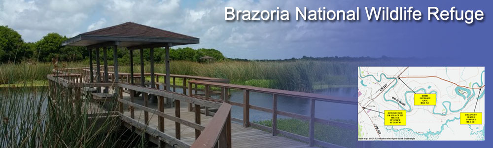
The Big Slough Recreation Area at Brazoria NWR was first opened in the late 1980s and is now available to the public on a full-time basis. An Information Pavilion near the entrance of the refuge has interpretive panels and also information on the self-guided auto tour including a brochure and cassette or compact disc.
Brazoria NWR is open every day sunrise to sunset. Restrooms are available near the Information Pavilion. |

|
 |
The gravel Big Slough Auto Tour runs 7.5 miles through the Big Slough Recreation Area, the heart of Brazoria NWR, wrapping around Olney and Teal ponds, and accessing Big Slough and Rogers Pond. The 3-mile entrance road from County Road 227 (which passes through private lands) also can provide wildlife viewing. County Road 227 cuts through some of the refuge's best bluestem prairie terrain. The gravel auto-tour is also open to biking.
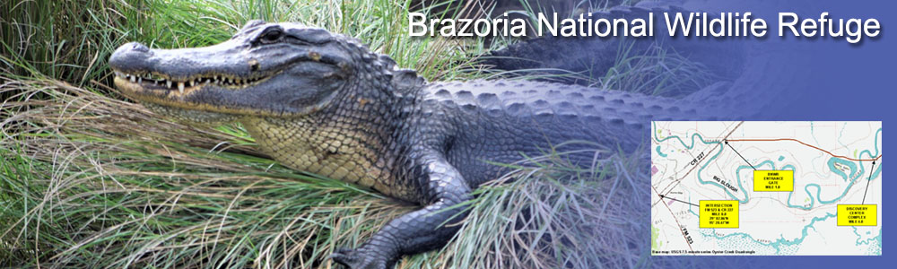
Brazoria NWR provides several footpaths in different settings, leading to a wide variety of habitat experiences. A wide variety of pathways is available, from a boardwalk to an abandoned railroad right-of-way to woodland and bayou trails. None of the walks is especially long, and all are on relatively flat terrain. Wandering off-trail here is not advised, however, because alligators and poisonous snakes reside in the taller grasses.
Boats are permitted on Nicks, Salt, and Lost lakes by way of the Intracoastal Waterway or Bastrop Bayou. Boats are not permitted to be launched from the Salt Lake Fishing Area parking lot. There are two boat ramps: one on the west bank of Bastrop Bayou, just off County Road 227 and the other off County Road 257 on the refuge's southwestern boundary. |
|
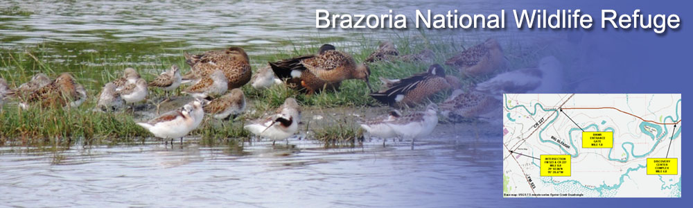
Teal Pond is a popular early-morning and late-evening stop for large numbers of geese, who come here to eat gravel, which aids their digestion. This same spot is also renowned for hawk, harrier, kestrel and white-tailed kite sightings. A universally accessible observation platform at Teal Pond offers viewing scopes and interpretive panels.
Rogers Pond, at the auto-tour's turnaround point, is a great place to observe wading birds, shorebirds, or waterfowl, depending on water levels and seasons. Middle Bayou Trail leads to views of birds that favor grasslands and prairies, including bobwhite quail, sandhill cranes, and four species of dove. Prime grounds to scout for alligators include the banks of Big Slough near Cox Lake because it is one of the Refuge's last bodies of water to dry up in a drought. Mottled Duck Marsh, off County Road 208 on the refuge's northern edge, rewards visitors on the lookout for waterfowl and shorebirds.
The boardwalk over Big Slough provides a close encounter with a lovely marsh crowded with spiky cattails and bulrush. For satisfying photos of wildflowers, visit the bluestem prairie along County Road 227. |
 |

|
 |
The Big Slough Boardwalk and Trail winds over and along the edges of a major slough on a raised boardwalk. The trail winds through low forests of yaupon trees and small clearings to an observation platform. Benches provide opportunities to rest and quietly observe wildlife. Loop trails branch and rejoin this primary trail, allowing for isolated observation of passerines perching in the trees and bushes. The main loop is 0.6 mile long; other loops run 0.1, 0.25, and 0.5 miles. The trailhead is at the Discovery Center.
Middle Bayou Trail follows two miles along an abandoned railroad right-of-way parallel to County Road 227 on the east side of Bastrop Bayou. The trailhead is at the Bastrop Bayou fishing pier.
The Cox Lake Trail passes through a salt-grass prairie among stands of salt cedars, ending at the western shore of Cox Lake. Along the way, the trail passes the Maddox Cedars monument, a small rest stop with an interpretive sign. The trailhead can be reached by vehicle at the eastern edge of the Big Slough Auto Tour.
―U.S. Fish & Wildlife Service
Texas Mid-coast National Wildlife Refuge Complex |
|